
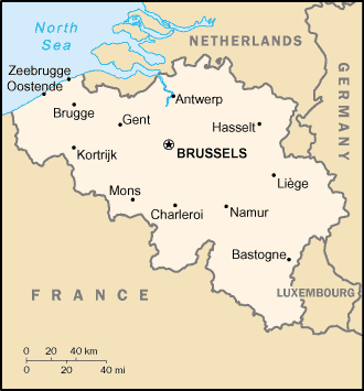
 Belgium is a low lying country on the North Sea coast in Western
Europe. It's part of the European Union and the Schengen
agreement and adopted the Euro as currency. With the majority
of West European capitals within 1,000 km of Brussels, the seat
of both the European Union and NATO, Belgium sits at the
crossroads of Western Europe. Its immediate neighbours are
France to the southwest, Luxembourg to the south east, Germany
to the east and the Netherlands to the north. Belgium has three
official languages: French, Dutch, and German. English is also
widely spoken.
Belgium is a low lying country on the North Sea coast in Western
Europe. It's part of the European Union and the Schengen
agreement and adopted the Euro as currency. With the majority
of West European capitals within 1,000 km of Brussels, the seat
of both the European Union and NATO, Belgium sits at the
crossroads of Western Europe. Its immediate neighbours are
France to the southwest, Luxembourg to the south east, Germany
to the east and the Netherlands to the north. Belgium has three
official languages: French, Dutch, and German. English is also
widely spoken.
Belgium is famous for chocolate and beer. Belgium also is famous
for its rich cultural heritage including its capital Brussels
with its famous architecture, palaces, its pubs, old shopping
malls and its lifestyle. But there are some more places worth a
visit. The second largest city is Antwerp (located to the north
of Brussels), a famous harbour town well known for diamond trade.
In Ghent, Brugge and other Flemish towns one can see
old Flemish trading towns. Belgium has a coastline (North Sea,
province West Flanders) and some "mountainous" (not exceeding
700 meters though...) areas like the Ardennes.
External links
http://en.wikipedia.org/wiki/Belgium: Wikipedia page on Belgium
http://wikitravel.org/en/article/Belgium: Wikitravel page on Belgium
http://www.visitantwerpen.be
http://www.visitflanders.be
http://www.visitbelgium.com
http://www.trabel.com: Belgian travel network
http://www.belgiumtheplaceto.be: Walloon tourist information
Practical
http://wikitravel.org/en/article/Belgium: Wikitravel page on Belgium
http://www.visitantwerpen.be
http://www.visitflanders.be
http://www.visitbelgium.com
http://www.trabel.com: Belgian travel network
http://www.belgiumtheplaceto.be: Walloon tourist information
Temperature: around 15-20 degrees Celsius (60-70 degrees Fahrenheit) in September
Electricity: 230 V, 50 Hz, two pin plugs
Currency: Euro, 1 EUR buys 1.24 USD (rate September 2004)
Close
Electricity: 230 V, 50 Hz, two pin plugs
Currency: Euro, 1 EUR buys 1.24 USD (rate September 2004)
Possibility to visit Paris (1:25 hour by train from Brussels South station
(Thalys-service)) and London (2:40 hour by train from Brussels South station
(Eurostar service)). In both cases, reservation is necessary.